Vehicle technology is ever advancing especially navigation apps like Google Maps. However, you can’t solely rely on them without some discerning common sense.
I use Google Maps almost exclusively because it is far better than the built-in vehicle navigation system. The features of Waze I find less useful. On my last trip to Iowa a few weeks ago of 16+ hours roundtrip driving, I noticed and experienced several changes appearing to be in test mode.

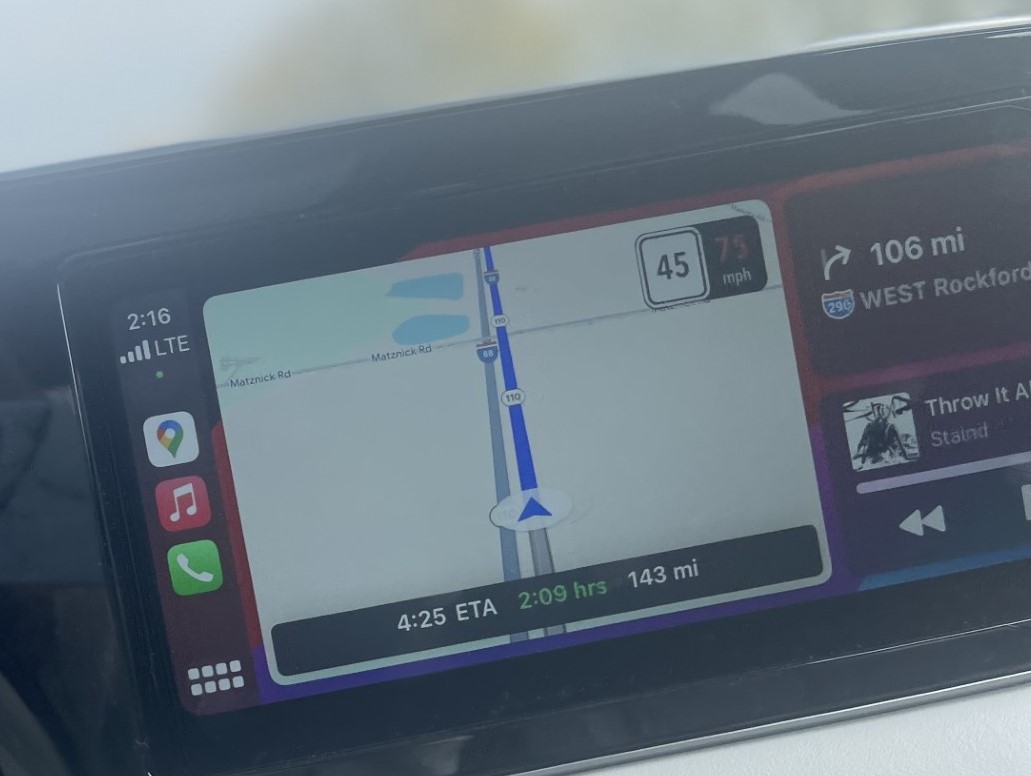
You’ll notice the 45 on the screen which is supposed to be the posted speed limit. I initially thought Google Maps was picking up the speed limit on a parallel road to the freeway. When I eventually passed a posted speed limit sign, I realized it was picking up the minimum speed limit on the freeway instead of the maximum speed of 70 mph. After several miles, it picked up the correct speed again. Your vehicle speed on the right fluctuates more than what is displayed on your vehicle dashboard.
The navigation voice of The GPS Girl now announced when stalled vehicles were on the shoulder ahead, but it was 100% inaccurate. Waze (also owned by Google) does this with much greater accuracy. It also announced when there was a speed trap ahead and this was surprisingly accurate. Obviously, the engineers had spent more time on this upgrade.
The next turn guidance of right on I-290 to Rockford I knew was wrong. There is massive on-going road construction on I-294/290 and it changes every time I drive through it. The interchange from I-88 to I-294 is also being reconfigured. You have to pay attention to signs and not rely on Google Maps as you navigate this road construction. Approaching the I-88 freeway fork, traffic slowed to a bumper-to-bumper crawl. I needed I-294 to O’Hare which split to the left and I-290 to Rockford went right.
The highway crews had done a great job of marking what lane you needed to be in for which freeway. Not only multiple overhead signs but also painted lane markings showed the way mile after mile as we crawled along. And yet, someone had not paid any attention to the signs or lane markings and solely relied on Google Maps. Because in the freeway fork median sat an SUV not knowing whether to go left or right as vehicle after vehicle passed them by on each side. You can guess what they uttered when they headed straight into that median.
Road construction on other freeways would prompt Google Maps to pop up a message asking if the lane closure was still there, Yes or No? Highway 30 in eastern Iowa is being expanded from 2 lanes to 4 and nearing completion. Google Maps still directs you to detour onto side roads and essentially flips out for several miles with errant directions that you must ignore until it picks up the original highway again.
Summary of Updates
Speed traps & weather alerts – good
Speed limits & stalls – bad
Road construction – ugly
Through it all, The GPS Girl along with your sensible reason and attention will get you where you need to be with the best/fastest route giving you weather alerts along the way, severe thunderstorms as I approached home. You have to be willing to give up some privacy (where you live but that is protected in other ways and where you go, just remember reputation follows you) for the greater good of advancing GPS technology. It’s a trade-off for safety and a sense of security away from home into the unknown.
AI is coming to Google Maps. It will include telling you what lane you are supposed to be in! In addition, it will allow users to see and report weather disruptions on the road, such as flooded, unplowed, and low-visibility areas. Google Maps is getting new AI features powered by Gemini | TechCrunch
This is a great comparison between Google Maps & Waze. Apple Maps provides more privacy but is limited to iPhone users and vetted as not as good. Google Maps vs Waze — which navigation app is best? | Tom’s Guide
Screen photo taken one-handed with the other hand on the steering wheel, with adaptive cruise control on, no vehicles around me with lane change alerts enabled.

